
In western Nevada, the chances of having one or more magnitude 6 or larger earthquakes in the next 50 years are fairly high, based on historical earthquake records and geologic evidence of numerous active faults that have produced earthquakes in the recent geologic past. Twelve earthquakes of magnitude 6 or greater, two of which were greater than magnitude 7, have occurred in western Nevada since the 1850s. The most recent event was the 1994 Double Spring Flat earthquake (magnitude 6) in a remote area south of Carson Valley. In populated areas, earthquakes of magnitude 6 and larger can cause significant damage and pose life-safety risks. The largest plausible earthquakes for this region are magnitude 7.5 or slightly larger, and there are many faults capable of earthquakes of magnitude 7 and larger. It is sobering to consider the impact that some of these earlier historical earthquakes would have on today's urban setting. Large earthquakes will inevitably occur in western Nevada--only the timing is uncertain.
Earthquakes are instantaneous events--there is usually no forewarning, and an earthquake that is large and close to a community can be an instantaneous disaster. Planning and preparing for a large earthquake in this earthquake-prone region makes good sense. To help emergency managers and other emergency responders plan response and recovery operations for damaging earthquakes in western Nevada, a scenario of a plausible major earthquake has been developed. This scenario, which describes in detail the effects and consequences of a hypothetical earthquake, has been published as NBMG Special Publication 20.
Promoting earthquake emergency planning is one of the goals of this publication. Agencies, companies, and families should develop emergency plans and evaluate the interaction of these plans with each other. Integrating emergency response plans and coordinating response and recovery are especially important in western Nevada where many different jurisdictions would be affected and must respond. Two states, five counties, and many local communities are involved in the scenario event. Emergency plans should incorporate contingency plans such as what to do if the emergency operating center has to be evacuated or what to do if the back-up generator fails. The potential for isolation of communities, especially mountainous communities, emphasizes the importance of preparedness.
Nonstructural hazards should be mitigated immediately in all homes, offices, and work places. Employees should take the initiative to secure their working environment for their own safety. Offices should be arranged so that file cabinets, bookshelves, merchandise, and equipment cannot block exits if they fall over, and so that there are safe places for occupants to take cover. Nonstructural mitigation at homes and dwellings is equally important, especially homes of emergency workers. If emergency workers' families are safe and their homes are secure, they will likely be available, physically and mentally, to assist with the emergency. Critical work places, such as emergency operating centers and fire stations, similarly need to be secure to assure overall functionality, minimize losses, and allow a more rapid response.
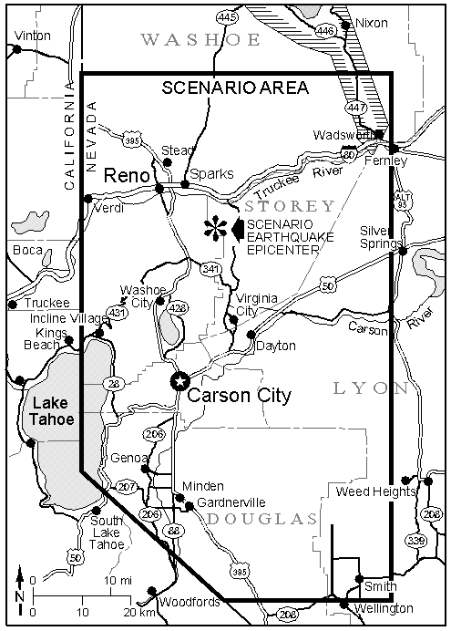
The Scenario Earthquake Map of scenario area
The scenario earthquake is magnitude 7.1 and is assumed to occur along the Carson Range fault system, which bounds the Carson Range on the east and extends from Reno to south of Woodfords, California. It is one of the largest and most active fault systems in Nevada. The geologic record indicates that an earthquake as large as magnitude 7.5 occurred along this system in Carson Valley about 500 to 650 years ago, producing a scar that is still quite prominent when shadowed by the late-afternoon sun. The northern part of the system appears to be somewhat less active: shorter fault lengths and smaller surface offsets than in Carson Valley suggest the largest earthquakes along the northern Carson Range fault system were about magnitude 7.1. The northern part of the Carson Range fault system projects as a discontinuous series of faults into southern Reno; these faults are involved in the scenario earthquake.
The parameters defined for the extent of fault rupture, displacements, and other details of the scenario earthquake are hypothetical, but the values used are consistent with the state of knowledge of the Carson Range fault system and with the record of historical earthquakes in the Basin and Range province. The scenario earthquake involves a zone of normal-slip surface faulting 20 miles long and up to 100 feet wide that extends from Washoe Valley, along the base of the Carson Range and into southwest Reno. The ground is offset 6.6 feet vertically over much of this distance, with a localized maximum of 13 feet and offsets of 1.6 feet and less in Reno.
Earthquake effects that are presented in the report include generalized shaking and damage, surface faulting, liquefaction, rockfalls, landslides, and snow avalanches.
Consequences
Buildings and structures
Schools. One university, three colleges, 15 high schools, and 103 middle and elementary schools are within the scenario area. Most of these buildings survive intact, but with significant nonstructural damage. Several are used as emergency shelters. About 52,000 students of high school age or younger attend school in the region that would be subjected to intense shaking. Of these, about 37,000 are in 77 elementary and middle schools. A school-time earthquake creates the problem of large numbers of students isolated from their families for a period of hours to a day or more. Nonstructural damage is significant in schools within areas of intense shaking. Nonstructural dangers in all schools in western Nevada should be mitigated prior to the occurrence of an actual earthquake.
Hospitals and medical facilities within the areas of intense shaking experience severe nonstructural damage because of the large amount of mobile equipment and unsecured materials. Consequently, there is a significant loss of hospital beds available following the scenario earthquake. The scenario also hypothesizes that one hospital has to be evacuated and is unusable for 2 days due to nonstructural damage and problems with back-up electric power.
Using recent California earthquakes as analogs, there are 7,000 hypothetical injuries, 1,400 of which require hospitalization during a daytime scenario event, or 4,000 injuries with 700 requiring hospitalization during a nighttime scenario event. An analysis of hypothetical hospital bed loss from the scenario event using 1995 data yields about 1,945 medical beds surviving the earthquake and available for use. Some victims requiring hospitalization need to be transported to other areas.
Fire and police activities are hampered initially following the event because of the large number of simultaneous emergency incidents, and because of structural and nonstructural damage to fire and police stations. The earthquake jams several doors of fire stations causing a delay in moving equipment. Transportation to emergency locations is difficult immediately after the earthquake because of cluttered and damaged roadways. Fifty earthquake-related fires are caused by the scenario earthquake; 20 of these start at the time of the earthquake and 30 begin within the following hour. These fires are concentrated in the urban areas, with a few in rural areas.
Emergency operating and coordinating centers in areas of strongest shaking have significant nonstructural damage delaying their activation after the scenario earthquake, unless they have mitigated nonstructural hazards prior to the event. Threatening damage and loss of utilities causes the relocation of some emergency operating centers.
Communications are hampered by equipment damage and call overloads requiring the additional use of ham radio operators. Information and specific intelligence about the disaster is spotty and communication with field units is intermittently difficult or impossible. Commercial radio and television are major sources of information, although these are affected as well, and at times have intermittent broadcasts; commercial media reports tend to focus on selected sites with severe damage, thus, immediately following the event they often do not give a balanced nor comprehensive picture of the disaster.
Hazardous materials (hazmat) incidents are particularly problematic during earthquakes due to the potential for numerous simultaneous and widespread incidents. With resources stretched thin, the potential exists for victims overcome by hazardous materials to go untreated for some time and for spills not to be cleaned up for weeks to months.
Transportation Systems. Several important transportation routes crossing the scenario area are affected by surface faulting, liquefaction, settlement, rockfalls and landslides, fallen debris, bridge and overpass damage, and bridge- abutment settlement. Interstate 80 is closed for three days west of Verdi and two days east of Reno due to numerous minor and a few major rockslides. The threat also exists of further rockslides from aftershocks. Interstate 80 through Reno and Sparks has limited, controlled use, and sections with overpass damage are closed for three or more days. Parts of U.S. Highway 395 are closed or have restricted use; several parts suffer liquefaction failure and take up to two days to repair or bypass.
The Reno/Tahoe International Airport experiences liquefaction causing settlement and some cracking of the runways. This delays usage of the airport for planes from one to two days. Significant nonstructural damage occurs at the airport terminal. The Carson City Airport has fairly extensive nonstructural damage and one of the expansion joints is opened up to 2 inches; this is small enough to allow use but must be watched for further deformation from aftershocks. The Douglas County Airport experiences severe liquefaction damage to its runways and some airport facilities. Other airports experience only nonstructural damage.
Electric power. The scenario earthquake has a significant impact on many of the major facilities that comprise the complex electrical power network serving the region. Up to 90% power loss occurs within the first 24 hours for services within 5 miles of the fault zone. Restoration of power for most cus- tomers in the affected area takes up to 6 days. Some areas are without power for more than a week due to damage of the underground distribution system.
Natural gas. The number of disruptions to gas service is in the tens of thousands, with most from people unnecessarily turning off their own gas. Twenty percent of the areas supplied by lines that cross the fault zone will be without gas for up to a week.
Water availability and quality vary after the scenario event. The scenario earthquake causes hundreds of breaks in water mains and service connections, loss of power, loss of some of the water transmission systems, and storage tank failures. Rockfalls damage transmission lines, and surface faulting and liquefaction damage distribution lines. Power loss at groundwater pumping stations impacts the available water supply. For some of those still having ser- vice, water is murky or of lower pressure than usual. In all cases, water is assumed to be contaminated. Boil-water orders and strict conservation measures are in effect for surviving water systems in areas of strong shaking.
Wastewater systems. There are numerous breaks in the wastewater collection systems where liquefaction, surface faulting, and landsliding occur, although many of these are not apparent. Power is lost at several lifts and wastewater treatment plants, only some of which have back-up power systems. Nonstructural damage to treatment facilities in areas of strong shaking close them down. Raw sewage leaks into the Truckee and Carson Rivers due to broken sewage line crossings and treatment plant bypasses. Inspection, repair, and restoration of wastewater systems takes days to weeks.
Petroleum. During the scenario earthquake some pipeline damage is caused by rockfalls and landslides. At the Sparks tank farm, four of the tanks are damaged; two rupture and leak. A fire is started at one of the two ruptured tanks. Roadway and transportation damage delays repairs to damaged pipelines for at least three days. Emergency response agencies and companies, such as fire departments, hospitals, hazmat crews, and portable generator services, need contingency plans for refueling vehicles and equipment during emergencies. Supplies for the first three days are limited to those on hand. Contracts need to be prearranged to have access to fuels available at the Sparks tank farm.
Conclusion
The scenario earthquake poses many serious geologic hazards, engineering risks, and impacts on important lifeline systems; it causes numerous injuries and has serious economic impacts on the area. Such an earthquake in the Reno-Carson City urban corridor is plausible based on geologic information. The potential impacts outlined above give a hint of the problems that will be faced when such an event occurs in the future. No specific economic loss projections have been made for the scenario event, but given the setting, the size of the event, and information from recent earthquakes, the scenario event could cost up to tens of billions of dollars in damage, disruption of services, and loss of revenues. Although this scenario addresses a hypothetical event, preparation and planning for such possible impacts will greatly reduce casualties, damages, and economic loss during any earthquake that might occur in the region.