
GEODESY & TECTONICS
Located within NBMG, the Nevada Geodetic Laboratory (NGL) conducts research in the field of space geodesy to study scientific problems that have both regional and global significance. The team uses extremely precise measurements from the Global Positioning System (GPS) and Interferometric Synthetic Aperture Radar (InSAR) to study active Earth movement. They also use GPS to study global patterns in surface mass loading and global-scale plate tectonic problems.
NGL studies have elucidated Nevada's natural hazards from active faults, earthquakes, and volcanism and have supported Nevada's push for clean energy by monitoring surface deformation associated with geothermal development. More recent research is focusing on vertical movements, how they relate to hydrological conditions in mountains and aquifers, what these movements may mean for active mountain growth, water resources, and climate change in Nevada.
The team's regional network of GPS stations and applications of data from that network help to understand crustal deformation induced by plate tectonic motions, human activities, and other geophysical factors.
Research faculty within the NGL participate in undergraduate and graduate education at UNR by teaching courses and advising graduate students.
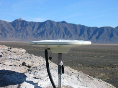
The Mobile Array of GPS for Nevada
Transtension (MAGNET)
GPS surveys are performed, usually for several months per year. These data give precise location and movement that results from active plate tectonic stretching of the Earth's crust, or other more localized effects such as volcanic or aquifer-related deformation. The data collected in MAGNET are combined with those from other networks in the western United States and are used to assess strain across active faults, earthquake hazards, seismic swarms, geothermal energy potential, mountain uplift, magmatic processes, effects of climate change on the
Earth system, and other phenomena of scientific and
societal interest.
MAGNET measures motion with such incredible precision that it is usually expressed in tenths of a millimeter per year. At a speed near that resolution it would take ~10 million years to move one mile! Because of its high precision, MAGNET easily measures the active tectonic stretching of the Great Basin, which is connected to Pacific Plate motion on the west side of the San Andreas fault. With MAGNET we can show that the Great Basin increases in area by about an acre each year, as California moves further west relative to Utah. This new territory is, however, distributed over a very large area and so cannot be pinned down to any particular location. However, it does make Nevada the fastest-growing state in the U.S., tectonically speaking.
Learn more about the Nevada Geodetic Laboratory at http://geodesy.unr.edu
 Home
Home