
Cinder Cone in Clayton Valley
Esmeralda County, Nevada
GPS Coordinates: N37°48.957', W117°38.323' (WGS 84)
LOCATION: Along Nevada Highway 265, north of Silver Peak and south of the intersection with
U.S. Highway 95 (also U.S. Highway 6).
WAYPOINTS: N37°48.921', W117°38.368': At turnoff from Highway 265 onto a dirt road to the
east.
This volcano is approximately 390,000 years old (part of the Pleistocene Epoch of the Quaternary
Period). It is 85 meters high and 715 meters in diameter. This cinder cone is composed of lots of
volcanic bombs and blocks of cinder (also called scoria, a volcanic rock with numerous holes form-
ed by gas
escaping from the cooling and crystallizing lava). The rock is termed a basalt, based on its mineralogy (dominantly plagioclase, clinopyroxene, orthopyroxene, and olivine) and chemistry (more magnesium, calcium, and iron and less silica, potassium, and sodium than other common igneous rocks).
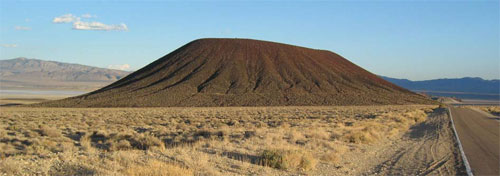
Figure 1. The cinder cone in Clayton Valley, looking southeast from Nevada Highway 265.
Minerals that can easily be identified in this area (mostly as crystals a few millimeters in size):
• Plagioclase (a type of feldspar), a solid solution of dominantly CaAl2Si2O8 and NaAlSi308 – clear
to milky white, with cleavage and tiny lamellae from crystal twins.
• Hornblende, a complex amphibole solid solution described chemically as
(Ca,Na,K)2-3(Mg,Fe,Mn)3-4(Al,Fe)2-1(Si,Al)8O22(O,OH,F)2 – generally black prisms with two
directions of cleavage at 60° and 120°.
• Clinopyroxene and orthopyroxene, solid solutions of dominantly MgSiO3, CaSiO3, and FeSiO3 –
generally black (sometimes dark green) prisms with two directions of cleavage at 90° but
also without visible cleavage and glassy, resembling obsidian.
• Olivine, a solid solution of dominantly Mg2SiO4 and Fe2SiO4 – olive or pale green, glassy.
• Magnetite, a solid solution of dominantly Fe3O4 and Fe2TiO4 – easily attracted to a magnet,
particularly if you put the magnet into the loose material eroded from the volcanic rocks.
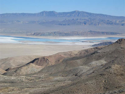
Figure 2. Lithium brine ponds in the central part of Clayton Valley, looking southeast
from Mineral Ridge.
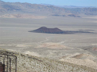
Figure 3. The cinder cone in Clayton Valley, looking northeast from Mineral Ridge.
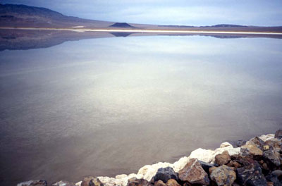
Figure 4. The cinder cone in Clayton Valley, looking north across a lithium brine pond,
in which the
cinder cone is reflected. Clayton Valley is the site of the largest lithium
mine in the United States of
America. It is an unusual mine in that the lithium occurs
in groundwater in sediments that fill the
valley. The lithium-rich water is pumped to
the surface and partially evaporated, past the saturation
point for halite (NaCl), the
salt that coats the rocks in the foreground of this picture. The lithium-rich
brine is then
processed to produce useful products for batteries, medicines, and other uses.
OBSERVATION: Geologists have noted that cinder cones commonly have rims that are not even in height, but one side tends to build up more than another, either because of prevailing wind directions (blowing the bombs and cinders down wind) or because of the dynamics of the eruption (erupting in a particular direction or erupting from an off-centered vent).
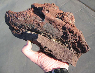
Figure 5. Volcanic bomb from the cinder cone in Clayton Valley.
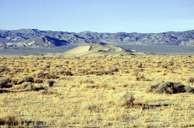
Figure 6. Sand dune at the south end of Clayton Valley.
QUESTION: Which side of the rim (N, NE, E, SE, S, SW, W, NW) of volcano is lowest in elevation?
FURTHER EXPLORATION NEARBY: Clayton Valley is an intriguing area geologically. Some features of interest include:
• the largest lithium mine in the United States of America – in the center of the valley
• active faults (ones that are likely to move during large earthquakes in the future) – on the
southeast side
• hot springs – on the west and east sides
• gold mines in metamorphic rocks – in the hills to the northwest
• a rhyolite lava flow that has large blocks of obsidian at its base – in the hills to the southeast
• a large sand dune – at the south end
References:
http://vulcan.wr.usgs.gov/Volcanoes/Nevada/description_nevada_volcanics.html#lunar_crater
Albers, J.P., and Stewart, J.H., 1972, Geology and mineral deposits of Esmeralda County, Nevada:
Nevada Bureau of Mines and Geology Bulletin 78, 80 p., with maps at 1:250,000 scale.
Wood and Kienle, 1990, Volcanoes of North America: United States and Canada: Cambridge University Press, 354 p., p.256-262. Zampirro, Danny, 2004, Hydrogeology of Clayton Valley brine deposits, Esmeralda County, Nevada: Nevada Bureau of Mines and Geology Special Publication 33, p. 271-280.
SPECIAL NOTES ABOUT ACCESS AT THIS SITE
Do not drive up the road on the south side of the cinder cone; it is not good, even for a four-wheel
drive vehicle. Hike from the base of the hill. To answer the question, you can hike around the
volcano to the east, or you can hike up the road onto the side of the volcano. At the end of the
road, you can follow a path further up the side of the volcano.
Hiking onto the volcano can strenuous across steep, rocky and loose ground. Wear sturdy hiking
boots. It is also advisable to wear gloves.
CAUTION IN USING GPS UNITS AND TOPOGRAPHIC MAPS
(Note that GPS coordinates are relative to a particular datum used to describe the nearly spherical
shape of the Earth’s surface. Most topographic maps published by the U.S. Geological Survey use
the North American Datum of 1927 (NAD 27), but most GPS units are set for either the North
American Datum of 1983 (NAD 83) or the World Geodetic System of 1984 (WGS 84). NAD 83 and
WGS 84 give nearly identical locations with hand-held GPS instruments, but NAD 27 can be off
considerably. In this part of Nevada, there is little change in latitude between the 1927 and 1983
data, but for longitude the datum of 1983 is shifted relative to the datum of 1927, such that, if you
use your GPS unit to measure a location using WGS 84, the point will plot on the U.S. Geological
Survey topographic map approximately 100 meters farther east than its true location on the map. If
your GPS unit is set to NAD 27, you need to look for the WGS 84 waypoint approximately 100
meters farther east from your location.)
BASIC VISITOR-USE AND PUBLIC SAFETY INFORMATION FOR PUBLIC LANDS IN NEVADA:
All visitors need to plan ahead and prepare for outings in Nevada’s public lands by:
• Knowing the regulations and special concerns for the area you are planning to visit (obeying
laws that prohibit collection or destruction of artifacts)
• Carrying a map and a GPS unit and/or compass (Maps are available for purchase at all BLM
offices and from the Nevada Bureau of Mines and Geology, www.nbmg.unr.edu.)
• Staying on existing roads and trails
• Staying away from all mine shafts and adits
• Planning for extreme weather, hazards, and emergencies
• Carrying a full-size spare tire, extra food, water, and warm clothing
• Being aware that cell phones DO NOT usually work in the rural areas away from the major
highways
• Leaving your travel plans with a responsible party, including the date and time of your
return
• Linking to “Tread Lightly and Leave No Trace” websites (www.treadlightly.org and
www.lnt.org).
Please see www.nbmg.unr.edu/ScienceEducation/EarthCaches/EarthCaches.html for more information about other Nevada
EarthCache and GeoCache sites of geologic interest. Thank you.
Contributed by J.G. Price and E.M. Price.
 Home
Home