
Volcanic Rocks near Project Faultless
Nye County, Nevada
GPS Coordinates: N38°38.237', W116°13.252' (WGS 84)
On January 19, 1968, the U.S. Atomic Energy Commission (the forerunner of the Department of Energy) detonated a nuclear bomb in a borehole at a depth of 975 meters (3,200 feet) below the large metal pipe that protrudes from the ground near this site, part of the Central Nevada Test Area. The device, with an announced yield of between 200 kilotons and one megaton, was detonated (a) to determine the environmental and structural effects that might be expected
should subsequent higher yield underground nuclear tests be conducted in this vicinity and (b)
to
study the behavior and characteristics of seismic signals generated by nuclear detonations
and
to
differentiate them from seismic signals generated by naturally occurring earthquakes. No
further tests were conducted near here, but more than 900 bombs were tested on the Nevada Test Site farther to the south. The test caused the ground to break, ironically, given the name of the shot – Project Faultless, creating new faults when the area close to ground zero sank into the underground cavity created by the blast. The collapse created numerous surface fractures up to 2,743 meters (9,000 feet) in length, with vertical fault displacements up to 5 meters (15 feet) and horizontal offsets up to 1 meter (3 feet).
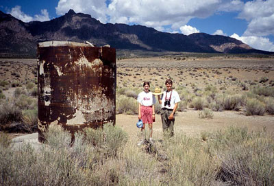
Figure 1. Metal pipe at ground zero, Project Faultless. The nearly horizontal light
line in the background is a break (scarp, see Figure 3) formed when the ground in
the foreground sank into the cavity created by the explosion.
Radioactivity from the blast was kept underground, although the U.S. Department of Energy and the Nevada Division of Environmental Protection are studying whether radioactivity could escape through groundwater flow.
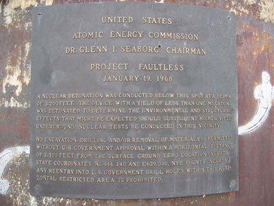
Figure 2. Plaque at ground zero.
The material at the surface is Quaternary (less than 1.8 million years old) alluvium – unconsolidated sediment eroded from older rocks. The rocks in the hills nearby to the west are dominantly ignimbrites (also called ash-flow tuffs), erupted violently from volcanoes about 30 to 33 million years ago, during the Oligocene Epoch of the Tertiary Period. Geologists identify these rocks as rhyolite and rhyodacite by their mineralogy (rich in such minerals as quartz, sanidine, plagioclase, biotite, and hornblende) and chemistry (rich in such elements as silica, potassium, and sodium and poor in such elements as magnesium, calcium, and iron relative to other common igneous rocks).
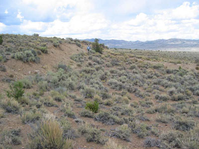
Figure 3. Scarp formed after the explosion. The ground on the right (east) dropped
down along the break in slope. Vegetation has not completely reestablished itself
along the fault scarp.
The nuclear test occurred in tuffaceous sediments (sandstones and siltstones derived from volcanic material) and nonwelded tuff that was altered to zeolite minerals millions of years ago. The alluvium above these rocks is 732 meters (2,400 feet) thick.
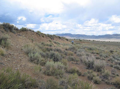
Figure 4. Scarp formed after the explosion. Vertical displacement here is approximately
3 meters (10 feet). Earthquakes of magnitudes generally greater than 6.5 also cause
surface faults, and larger earthquakes generally have larger displacements across the faults.
REFERENCES:
Kleinhampl, F.J., and Ziony, J.I., 1985, Geology of northern Nye County, Nevada: Nevada Bureau of Mines and Geology Bulletin 99A, 171 p., with maps at 1:250,000 scale.
http://ndep.nv.gov/cnta/CNTASubsurface.html
http://www.globalsecurity.org/wmd/library/report/enviro/eis-0243/eis0243_44.html
SPECIAL NOTES ABOUT ACCESS AT THIS SITE
Hiking is easy in this area.
CAUTION IN USING GPS UNITS AND TOPOGRAPHIC MAPS
Note that GPS coordinates are relative to a particular datum used to describe the nearly spherical shape of the Earth’s surface. Most topographic maps published by the U.S. Geological Survey use the North American Datum of 1927 (NAD 27), but most GPS units are set for either the North American Datum of 1983 (NAD 83) or the World Geodetic System of 1984 (WGS 84). NAD 83 and WGS 84 give nearly identical locations with hand-held GPS instruments, but NAD 27 can be off considerably. In this part of Nevada, there is little change in latitude between the 1927 and 1983 data, but for longitude the datum of 1983 is shifted relative to the datum of 1927, such that, if you use your GPS unit to measure a location using WGS 84, the point will plot on the U.S. Geological Survey topographic map approximately 100 meters farther east than its true location on the map. If your GPS unit is set to NAD 27, you need to look for the WGS 84 waypoint approximately 100 meters farther east from your location.)
BASIC VISITOR-USE AND PUBLIC SAFETY INFORMATION FOR PUBLIC LANDS IN NEVADA:
All visitors need to plan ahead and prepare for outings in Nevada’s public lands by:
• Knowing the regulations and special concerns for the area you are planning to visit (obeying
laws that prohibit collection or destruction of artifacts)
• Carrying a map and a GPS unit and/or compass (Maps are available for purchase at all BLM
offices and from the Nevada Bureau of Mines and Geology, www.nbmg.unr.edu.)
• Staying on existing roads and trails
• Staying away from all mine shafts and adits
• Planning for extreme weather, hazards, and emergencies
• Carrying a full-size spare tire, extra food, water, and warm clothing
• Being aware that cell phones DO NOT usually work in the rural areas away from the major
highways
• Leaving your travel plans with a responsible party, including the date and time of your
return
• Linking to “Tread Lightly and Leave No Trace” websites (www.treadlightly.org and www.lnt.org)
Please see www.nbmg.unr.edu/ScienceEducation/EarthCaches/EarthCaches.html for more information about other Nevada
EarthCache and GeoCache sites of geologic interest. Thank you.
Contributed by J.G. Price and E.M. Price.
 Home
Home