
GEOLOGIC HAZARDS
Nevada is at risk from earthquakes, flooding, landslides, and other hazards. NBMG scientists study these hazards to reduce losses, enhance building codes, plan land usage, and educate Nevadans about preparedness.
NBMG geoscientists conduct research along active earthquake faults to determine the size, timing, and recurrence of prehistoric earthquakes, essential information for better characterizing earthquake hazards across the state. Earthquake studies include new geologic and fault trace mapping, subsurface trenching investigations, geochronological analyses, and acquisition and analysis of high-resolution topographic data. Recent and ongoing fault investigations include studies of the Frenchman Mountain and Eglington faults in Las Vegas Valley, the Kings Canyon fault zone in Carson City, and the Freds Mountain, Warm Springs Valley, and Lemmon Valley faults in the North Valleys of Reno.
Las Vegas Valley Fault Study
The NBMG is the lead agency in a comprehensive earthquake source investigation being conducted in Las Vegas Valley. Studying these poorly understood faults in a highly urbanized setting is challenging, and NBMG has assembled an expert team of scientists from NBMG, UNLV, and the USGS to tackle it. The results of this four-year study will give needed insight into the seismic potential of faults in the valley and will provide the hazard assessment needed for development and building construction.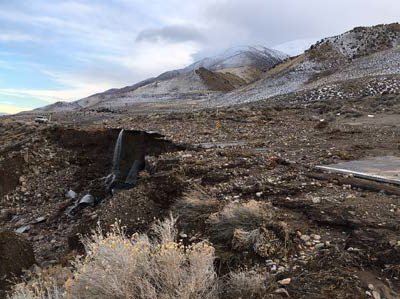
Geologic Mapping and Hazards
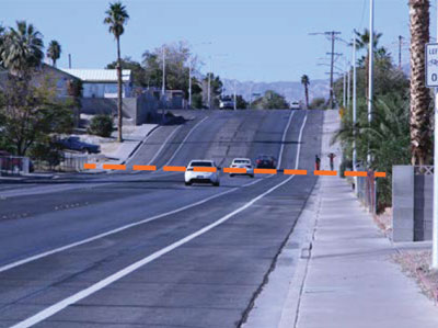
Mapping by NBMG staff has identified geologic hazard areas and helped better delineate the locations of flood and landslide hazards in the Reno-Carson City urban corridor. This mapping has utilized newly acquired high-resolution topographic data known as lidar. Recent urban river and canal flooding illustrates the need to better define flood and landslide source areas and areas of potential impact. The NBMG is developing plans to increase the coverage of lidar data throughout the state and expand hazard mapping to other susceptible areas.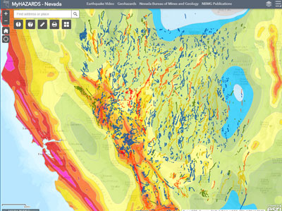
Preparedness and Public Access
NBMG provides state-of-the-art hazard and preparedness information to officials, emergency responders, and the Nevada public through the MyHazards-Nevada website, participation in the Nevada Resilience Commission and Western States Seismic Policy Council, and coordination of the update of the Nevada Enhanced Hazard Mitigation Plan (NEHMP). NBMG staff interact with emergency management personnel, as needed, and recently provided rapid response and situational monitoring during the January 2017 floods in western Nevada along the Truckee and Carson rivers and the Hawthorne earthquake sequence (three magnitude >5 earthquakes on Dec. 28, 2016). NBMG was contracted by the Nevada Division of Emergency Management to update the hazard and mitigation sections and the assembly of the NEHMP, which resulted in a rapid adoption by FEMA. The approved NEHMP provides Nevada 'enhanced status',making the state eligible for federal mitigation funds in
the event of a natural disaster.
 Home
Home