
Ventifact Ridge
GPS Coordinates: N39° 49.742', W119° 45.281'
Short Description:
Park at the coordinates given and take a short hike (a few hundred yards) up to the ridge crest to the west to examine some rocks that tell a tale of explosive volcanic activity millions of years ago followed much later by sandblasting by sediment-laden winds over a few thousand years.
Long Description:
All along the crest of the low ridge to the west of the coordinates listed are winderoded outcrops
of a pinkish colored rock called welded tuff. This particular rock unit has a name – it is called the
tuff of Whisky Springs, more informally known as the “Big Sanidine tuff”. Tuff is a volcanic rock that forms when material is erupted from a volcano or caldera. When a volcano erupts explosively, ash, fragments of pumice and other volcanic rock fall back to earth and travel down the slopes of the volcano and are deposited in topographically low areas. If the material is still very hot, it will form what is known as a “welded tuff” like this one, where the interstitial material is a volcanic glass surrounding mineral crystals and lithic fragments. Pumice fragments are often constituents of tuffs and may be
flattened by the weight of the overlying volcanic material. Look for flattened pumice fragments embedded in the matrix of the tuff. Also look for small glassy, rectangular–shaped crystals of the mineral sanidine - a high temperature form of feldspar- in the tuff. They are only a few millimeters long, but will sparkle in the sunlight.
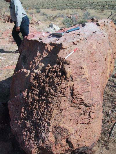
Wind-eroded boulder of welded tuff.
This rock has been radiometrically dated at 30.75 million years, a time that
predates the rise of the Sierra Nevada Range to the west. The Big Sanidine tuff
has been found occupying low areas of the paleotopography over hundreds of
square miles of northwestern Nevada and adjacent California. Mapping of the
distribution and thickness of the tuff by geologists with the Nevada Bureau of
Mines and Geology suggests that the volcanic caldera that was the source of the
tuff was in the Clan Alpine Range in Eastern Churchill County, nearly 100 miles
east of here!
Walk to the top of the ridge, to the rocks located at waypoint: N39° 49.714',
W119° 45.405'
Once on top of the ridge, look for boulders of the tuff that have been eroded and
carved by wind action. Sediment-laden winds have “sand-blasted” some of the
rocks in exposed places leaving characteristic pitted and grooved surfaces. The
pitted surfaces are oriented roughly perpendicular to the prevailing wind
direction, and the grooved surfaces are roughly parallel to the prevailing wind
direction. These wind-eroded rocks are called “ventifacts.”
The information on this EarthCache site is contained in a field trip road log
entitled "In Search of the Right Tuff" that may be downloaded and printed from
the website of the Nevada Bureau of Mines and Geology website at:
(www.nbmg.unr.edu/dox/e41.pdf)
You can follow the road log directions to other nearby sites of geologic interest.
THIS IS A HIGH OFF-ROAD-VEHICLE USE AREA FAVORED BY DIRT BIKERS
AND OTHER ATV AND QUAD ENTHUSIASTS, SO USE CAUTION IN
EXPLORING THIS EARTHCACHE SITE.
How do people log this Earthcache?
Find several ventifacts and compare the orientation of the pits and grooves to try to determine the prevailing wind direction that caused the features. E-mail that information to the site developer, and take a photograph of your group and/or GPS unit at the Ventifact Ridge EarthCache site. Don't forget to include the number of people in your group.
CAUTION IN USING GPS UNITS AND TOPOGRAPHIC MAPS
Note that GPS coordinates are relative to a particular datum used to describe the nearly spherical shape of the Earth’s surface. Most topographic maps published by the U.S. Geological Survey use the North American Datum of 1927 (NAD 27), but most GPS units are set for either the North American Datum of 1983 (NAD 83) or the World Geodetic System of 1984 (WGS 84). NAD 83 and WGS 84 give nearly identical locations with hand-held GPS instruments, but NAD 27 can be off considerably. In this part of Nevada, there is little change in latitude between the 1927 and 1983 data, but for longitude the datum of 1983 is shifted relative to the datum of 1927, such that, if you use your GPS unit to measure a location using WGS 84, the point will plot on the U.S. Geological Survey topographic map approximately 100 meters farther east than its true location on the map. If your GPS unit is set to NAD 27, you need to look for the WGS 84 waypoint approximately 100 meters farther east from your location.)
BASIC VISITOR-USE AND PUBLIC SAFETY INFORMATION FOR PUBLIC LANDS IN NEVADA:
All visitors need to plan ahead and prepare for outings in Nevada’s public lands by:
• Knowing the regulations and special concerns for the area you are planning to visit (obeying
laws that prohibit collection or destruction of artifacts)
• Carrying a map and a GPS unit and/or compass (Maps are available for purchase at all BLM
offices and from the Nevada Bureau of Mines and Geology, www.nbmg.unr.edu.)
• Staying on existing roads and trails
• Staying away from all mine shafts and adits
• Planning for extreme weather, hazards, and emergencies
• Carrying a full-size spare tire, extra food, water, and warm clothing
• Being aware that cell phones DO NOT usually work in the rural areas away from the major
highways
• Leaving your travel plans with a responsible party, including the date and time of your
return
• Linking to “Tread Lightly and Leave No Trace” websites (www.treadlightly.org and www.lnt.org)
Please see www.nbmg.unr.edu/ScienceEducation/EarthCaches/EarthCaches.html for more information about other Nevada
EarthCache and GeoCache sites of geologic interest. Thank you.
Contributed by D.D. LaPointe.
 Home
Home