
Moon Rocks
GPS Coordinates: N39° 50.960 W119° 44.378
Short Description
This eerily beautiful landscape looks more like a movie set than a naturally occurring landform. The rounded, strangely patterned boulders tell a story of geologic processes at work. Stay on established dirt roads in the Hungry Valley Recreational area to access this site.
Long Description
This area of rounded granite outcrops on the north side of the road is informally called “Moon Rocks” by locals. Granite is a common igneous rock that cooled from a magma deep underground at a slow enough rate for large crystals to form, big enough to be seen without the aid of a microscope. The minerals you can see in the granite if you look closely are white feldspar, gray quartz, greenish black hornblende, and brownish black biotite mica. If you explore the granite outcrops a few hundred feet farther north you may also find areas where the granite contains some tiny reddish-brown garnet crystals.
The rounded erosional pattern of the granite bedrock outcrops here is called spheroidal weathering and is typical of granites worldwide. The granite has been jointed or cracked in a rectilinear pattern to form blocks. Water seeps into the rocks along the cracks and breaks down the minerals in the granite. The corners of the jointed blocks are most susceptible to weathering because water attacks them from 3 sides at once. As the corners decompose and are eroded away, the remaining granite develops the characteristic rounded stacked boulder landscape we see here.
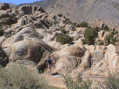
Figure 1. Moon Rocks spheroidally weathered granite.
In several places on the rounded granite boulders, you can see concentric rings of reddish-brown to yellowish brown iron-oxide staining. These are called “liesegang bands,” (pronounced “leez-ah-gang”) and they show the path of the water infiltrating the rocks as it oxidizes the iron contained in the darker minerals biotite and hornblende in the granite.
Several fault planes cut the granite of the Moon Rocks area. Movement along these planes is marked by grooves in the smooth surface, known as “slickensides,” which indicate the direction of movement along the fault. The black mineral that forms along some of these fault planes is tourmaline.
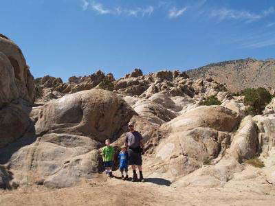
Figure 2. My guys at the Moon Rocks area.
There are some pegmatite zones in the granite of Moon Rocks; the minerals in pegmatite are coarser grained than the surrounding granite. As you walk around this area, look for pieces of the minerals feldspar and quartz, which weather out of these pegmatite zones.
This site is best accessed via the Pyramid Highway (Rte. 445) north of Reno Nevada, to Winnemucca Ranch Road, to a dirt road on the left at waypoint N39° 51.232', W 119° 43.447' marked by a sign reading "Hungry Valley Recreational Access." Please stay on established roads.
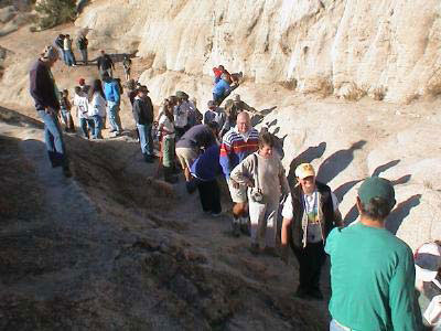
Figure 3. Field trippers walk up a fault plane at Moon Rocks.
The information on this EarthCache site is contained in a field trip road log
entitled "In Search of the Right Tuff" that may be downloaded and printed from
the website of the Nevada Bureau of Mines and Geology website at:
(www.nbmg.unr.edu/dox/e41.pdf). This road log contains directions to and
information about other nearby sites of geologic interest.
THIS IS A HIGH OFF-ROAD-VEHICLE USE AREA FAVORED BY DIRT BIKERS
AND OTHER ATV AND QUAD ENTHUSIASTS, SO USE CAUTION IN
EXPLORING THIS EARTHCACHE SITE.
How do people log this EarthCache?
To log this EarthCache, go to the specified coordinates and use the compass function on your GPS unit to record the direction that most of the joints (cracks, fractures) in the granite are lined up. These are the planes along which water infiltrates to cause the spheroidal weathering pattern and liesegang banding. Email the site developer with this information. Also take a photo of your group and/or GPS unit at the Moon Rocks EarthCache site. Be sure to include the number of people in your group visiting the site.
CAUTION IN USING GPS UNITS AND TOPOGRAPHIC MAPS
Note that GPS coordinates are relative to a particular datum used to describe the nearly spherical shape of the Earth’s surface. Most topographic maps published by the U.S. Geological Survey use the North American Datum of 1927 (NAD 27), but most GPS units are set for either the North American Datum of 1983 (NAD 83) or the World Geodetic System of 1984 (WGS 84). NAD 83 and WGS 84 give nearly identical locations with hand-held GPS instruments, but NAD 27 can be off considerably. In this part of Nevada, there is little change in latitude between the 1927 and 1983 data, but for longitude the datum of 1983 is shifted relative to the datum of 1927, such that, if you use your GPS unit to measure a location using WGS 84, the point will plot on the U.S. Geological Survey topographic map approximately 100 meters farther east than its true location on the map. If your GPS unit is set to NAD 27, you need to look for the WGS 84 waypoint approximately 100 meters farther east from your location.)
BASIC VISITOR-USE AND PUBLIC SAFETY INFORMATION FOR PUBLIC LANDS IN NEVADA:
All visitors need to plan ahead and prepare for outings in Nevada’s public lands by:
• Knowing the regulations and special concerns for the area you are planning to visit (obeying
laws that prohibit collection or destruction of artifacts)
• Carrying a map and a GPS unit and/or compass (Maps are available for purchase at all BLM
offices and from the Nevada Bureau of Mines and Geology, www.nbmg.unr.edu.)
• Staying on existing roads and trails
• Staying away from all mine shafts and adits
• Planning for extreme weather, hazards, and emergencies
• Carrying a full-size spare tire, extra food, water, and warm clothing
• Being aware that cell phones DO NOT usually work in the rural areas away from the major
highways
• Leaving your travel plans with a responsible party, including the date and time of your
return
• Linking to “Tread Lightly and Leave No Trace” websites (www.treadlightly.org and www.lnt.org)
Please see www.nbmg.unr.edu/ScienceEducation/EarthCaches/EarthCaches.html for more information about other Nevada
EarthCache and GeoCache sites of geologic interest. Thank you.
Contributed by D.D. Lapointe.
 Home
Home