
Science of the Comstock - Environment
Home | Tour | Physics | Chemistry | Earth Science | Environment | Scams | Lesson Plans
Environment Topics:
Introduction | Urbanization | Mine Wastes | Influence of Mining
Influence of Mining
Introduction
The Influence of Mining on the Areas near Virginia City
Opening of the mines in Virginia City changed Nevada, the United States, and even influenced the world. The prospect of great riches to be merely picked up from the ground brought people and related industries to the relatively uninhabited Nevada Territory. This picture looking southeast from the top or the highest mountain above Virginia City, Mount Davidson, gives an idea of the area around Virginia City today. The picture shows the southern tip of Virginia City and the green of the Carson River in the background.

The extent of mining throughout the time from the discovery of the Comstock Lode to the present can be seen in the Nevada Bureau of Mines and Geology map of mining districts in Nevada. The geology underlying the state of Nevada is shown in the Generalized Geology Map of Nevada also published by the Nevada Bureau of Mines and Geology.
Supplying the Mines
Mining the silver of the Comstock Lode in Virginia City took materials and people. Here is a picture of Virginia City today, looking east from the top of Mount Davidson. Notice the lack of trees and some bare ground. Both of these conditions are a result of the lack of water in the area where normal yearly precipitation is about 8 inches a year. The location of the city, where the silver and gold were found, meant that all of the materials had to be brought in.
Consider first, the materials needed.
Some Sources of Minerals for Mining
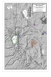
Processing the ore required chemicals that had to be acquired from other sources, ultimately mined. Of course, local sources of the chemicals were less expensive than ones that required shipping. The shaded relief map of the Truckee River drainage shows the locations of some sources of salt in purple and the locations of some sources of copper in brown.
The salt needed for the Patio Process was mined in the dry lakes and marshes nearby. See the article by Joe Tingley published in the NBMG Quarterly Newsletter, Nevada Geology, Summer, 1990: Salt and Silver. Of course, this meant that other economic systems had to develop in order to support this additional mining.
The copper sulfate needed for the Patio Process was mined in various places in the modern Yerington Mining District in present day Lyon County. (Moore, J. G., Geology and Mineral Deposits of Lyon, Douglas, and Ormsby Counties, Nevada, Nevada Bureau of Mines and Geology Bulletin 75, Mackay School of Mines, University of Nevada, Reno, Nevada, 1969, p. 22)
view larger version
Some Sources of Wood for Mining
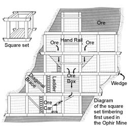
The area around Virginia City had very few trees for wood to serve as fuel or building material. These and sagebrush were quickly used up in the mills. In addition to wood for fuel, square set timbering placed in the mines required wood that was straight and strong. The diagram of square set timbering is adapted from Purkey, B.W. and Garside, L.J., Geologic and Natural History Tours in the Reno Area, Nevada Bureau of Mines and Geology Special Publication 19, University of Nevada, Reno, 1995; p, 60. This photo is of a model of square set timbering found in the Nevada State Museum in Carson City.

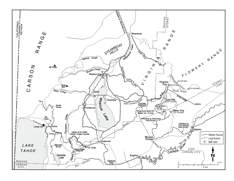
The trees around Lake Tahoe were a nearby source of wood. Water flumes were built to bring the logs down from the Sierra Nevada into the valleys between the Sierras and Virginia City (Washoe and Carson Valleys). The wood was processed in these valleys and then taken by the Virginia and Truckee (V & T) train up the mountains of the Virginia Range to Virginia City. See the map of the Virginia City-Lake Tahoe area for some locations of flumes and rail lines. The Lake Tahoe forests are marked on the shaded relief map in green.
view larger version
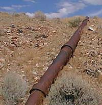
Some Sources of Water for Mining
The first problem for mining was a water source. The Virginia Range receives some snow in the winters but because Virginia City is high in the mountains, the water from that snow flows down to the Carson River below leaving little water in Virginia City. Eventually, water was piped from a small lake, Marlette Lake, above Lake Tahoe to Virginia City. Read related article on Siphons. See the map of Virginia City-Lake Tahoe area for the location of the "inverted siphon" that still provides water for Virginia City today. On the shaded relief map, Marlette Lake and an approximate tracing of the water flumes and siphon that provide water to Virginia City are shown in blue.
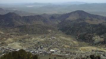
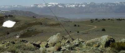
This picture shows the view from the top of Mount Davidson looking west across Washoe Lake toward the Sierra Nevada. Lake Tahoe is beyond the snowy mountains, the Carson Range in the background. Marlette Lake is near the low spot in the mountains to the left of the wire that supports transmission towers.
 Home
Home