
Black Rock Lava Flow
Nye County, Nevada
GPS Coordinates: N38°28.414', W116°00.583' (WGS 84)
LOCATION: Along a dirt road north of U.S. Highway 6 between Tonopah and Ely.
WAYPOINTS: N38°27.679', W116°00.319': on the north side of the U.S. Highway 6, where it intersects with the road to the Black Rock Lava Flow.
N38°28.301', W116°00.655': parking lot.
This Quaternary (less than 1.8 million years old) lava flow is part of the Lunar Crater volcanic field. Lunar Crater, several kilometers to the southwest, is a maar, a type of volcano formed when magma approaching the surface from deep within the Earth violently boils the groundwater and tosses volcanic bombs (pieces of lava) onto the surface, often leaving a circular hole that later fills with a lake (if there is lots of water). At Lunar Crater, the groundwater is too deep below the surface for a lake to form. There is a different kind of volcano here—a cinder cone. Cinder (also called scoria) is a volcanic rock with numerous holes formed by gas escaping from the cooling and crystallizing lava. When the volcano erupted, it tossed cinder into the air, and the heavy pieces of cinder landed close to the volcanic vent, progressively building the cone shape. This volcano also erupted a lava flow from the same vent that built the cinder cone.
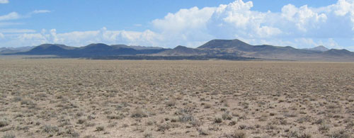
Figure 1. Black Rock Lava Flow (dark band in the middle of the photograph) and cinder
cone (highest hill), looking northeast.
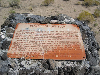
Figure 2. Sign erected by the U.S. Bureau of Land Management.
This particular lava flow has a variety of crystals that formed from cooling magma deep within the Earth. The rock is termed a basalt, based on its mineralogy (dominantly plagioclase, clinopyroxene, and olivine) and chemistry (more magnesium, calcium, and iron and less silica, potassium, and sodium than other common igneous rocks).
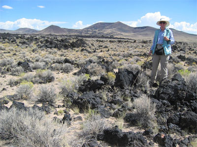
Figure 3. Lava flow surrounded by sand, with cinder cone in background.
Large crystals can be found embedded in the volcanic rock, and some crystals can be found in the sand around the hard rocks. They include olivine (and the gem variety peridote), clinopyroxene, hornblende, plagioclase, anorthoclase, and magnetite. Some crystals are several centimeters long.
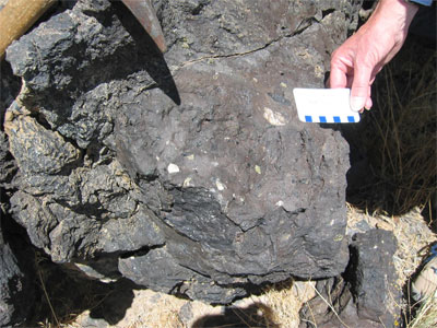
Figure 4. Block of basalt with large crystals of feldspar (presumably plagioclase
–white), clinopyroxene (black), and olivine (olive green).
References:
Wood and Kienle, 1990, Volcanoes of North America: United States and Canada: Cambridge
University Press, 354 p., p. 256–262.
http://vulcan.wr.usgs.gov/Volcanoes/Nevada/description_nevada_volcanics.html#lunar_crater
Kleinhampl, F.J., and Ziony, J.I., 1985, Geology of northern Nye County, Nevada: Nevada Bureau
of Mines and Geology Bulletin 99A, 171 p., with maps at 1:250,000 scale.
SPECIAL NOTES ABOUT ACCESS AT THIS SITE
Hiking on the lava flow can be dangerous, because the rocks are sharp and sometimes loose. Wear sturdy hiking boots. It is also advisable to wear gloves.
CAUTION IN USING GPS UNITS AND TOPOGRAPHIC MAPS
(Note that GPS coordinates are relative to a particular datum used to describe the nearly spherical shape of the Earth's surface. Most topographic maps published by the U.S. Geological Survey use the North American Datum of 1927 (NAD 27), but most GPS units are set for either the North American Datum of 1983 (NAD 83) or the World Geodetic System of 1984 (WGS 84). NAD 83 and WGS 84 give nearly identical locations with hand-held GPS instruments, but NAD 27 can be off considerably. In this part of Nevada, there is little change in latitude between the 1927 and 1983 data, but for longitude the datum of 1983 is shifted relative to the datum of 1927, such that, if you use your GPS unit to measure a location using WGS 84, the point will plot on the U.S. Geological Survey topographic map approximately 100 meters farther east than its true location on the map. If your GPS unit is set to NAD 27, you need to look for the WGS 84 waypoint approximately 100 meters farther east from your location.)
BASIC VISITOR-USE AND PUBLIC SAFETY INFORMATION FOR PUBLIC LANDS IN NEVADA:
All visitors need to plan ahead and prepare for outings in Nevada's public lands by:
• Knowing the regulations and special concerns for the area you are planning to visit (obeying laws that prohibit collection or destruction of artifacts)
• Carrying a map and a GPS unit and/or compass (Maps are available for purchase at all BLM offices and from the Nevada Bureau of Mines and Geology, www.nbmg.unr.edu.)
• Staying on existing roads and trails
• Staying away from all mine shafts and adits
• Planning for extreme weather, hazards, and emergencies
• Carrying a full-size spare tire, extra food, water, and warm clothing
• Being aware that cell phones DO NOT usually work in the rural areas away from the major highways
• Leaving your travel plans with a responsible party, including the date and time of your return
• Linking to "Tread Lightly" and "Leave No Trace" websites (www.treadlightly.org and www.lnt.org)
Please see www.nbmg.unr.edu/ScienceEducation/EarthCaches/EarthCaches.html for more information about other Nevada EarthCache and GeoCache sites of geologic interest. Thank you.
Contributed by J.G. Price and E.M. Price.
 Home
Home