
Warm Springs Mountain Dike Swarm
GPS Coordinates: N39° 49.315', W119° 4660'
Short Description
The Warm Springs Mountain Dike Swarm EarthCache site is a great spot to find and identify a variety of igneous rocks in one remote and beautiful area with a great view, north of Reno. Deer, antelope, hawks, and coyotes may be seen here at some times of the day. Kids will enjoy the natural playground afforded by the jumble of bouldery outcrops. Nearby junipers offer enough shade for a comfortable lunch stop even in summer heat. The site is accessed via dirt roads.
Long Description
As you explore the hillside surrounding this site you will find many outcrops of different types of
igneous rocks. The most prevalent country rock you will find here is a gray and black speckled intrusive rock called quartz monzodiorite. It is similar to the rock that makes up most of Dogskin Mountain to the north. Nevada Bureau of Mines & Geology
geologists believe that the rock is about 90–100 million years old (Cretaceous age) meaning that it crystallized from a magma at that time, hundreds of feet deep in the Earth and has since then been uplifted along faults and exposed by erosion.
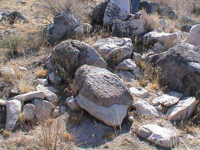
Figure 1. A variety of igneous rock types may be seen at this site.
Here on the crest and west flank of Warm Springs Mountain, the quartz monzodiorite is intruded or cut by a series of dikes of igneous rocks of different compositions and textures. Look for very light colored quartz-feldspar-mica rock called aplite. The rock is similar to granite, but it lacks the dark minerals that give granite its speckled "salt-and pepper" appearance. The very large-grained version of aplite is called pegmatite. You should be able to find dikes of aplite grading into the coarser pegmatite. Also present are dikes of rock that is darker and finer-grained than the quartz monzodiorite; these are called "microdiorite". Try to work out the relative ages of the different igneous rock types, keeping in mind the
"Law of cross-cutting relations" that says any rock that cuts across another rock is younger than the rock it cuts. Find your favorite boulder and enjoy a lunch or snack while you ponder the sequence of intrusions!
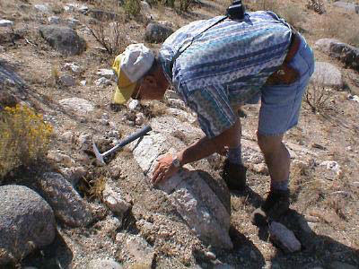
Figure 2. A geologist examines a pegmatite dike at the site.
Also look for ventifacts here—rocks that have been pitted, grooved, and smoothed by wind erosion. The sand-blasted features may be more subtle than at the nearby Ventifact Ridge Earthcache site. Do they indicate a prevailing wind direction?
To reach the Warm Springs Mountain Dike Swarm, drive north from Reno on the Pyramid Highway (Route 445) about 20 miles, turn left on Winnemucca Ranch Road for about 6 miles, then turn left on a dirt road at the Bureau of Land Management sign that reads: "Hungry Valley Recreational Access"
At about four miles, turn left on unnamed dirt road to the south. Waypoint for the south turn off the main dirt road is: N39° 50.139', W119° 46.419'
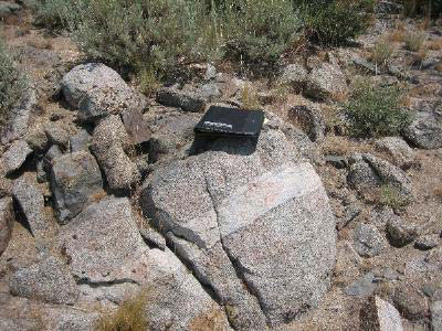
Figure 3. One of many dikes at the Warm Springs EarthCache.
After about three miles, turn left again on a very straight minor dirt road. Waypoint for the east turn onto minor dirt road is: 39° 49.273', 119° 47.234'
Please stay on established dirt roads and do not drive "off-road."
The last few hundred yards of the dirt access road to the site are steep and rocky and may require 4WD, but one can drive to within a short hike of a few hundred yards with any reasonably high clearance vehicle.
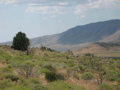
Figure 4. View from the Warm Springs Dike Swarm EarthCache.
The information on this EarthCache site is contained in a field trip road log entitled "In Search of the Right Tuff" that may be downloaded and printed from the website of the Nevada Bureau of Mines and Geology website at: (www.nbmg.unr.edu/dox/e41.pdf). You can follow the road log directions to other nearby sites of geologic interest.
How do people log this Earthcache?
To log this EarthCache site, go to the outcrop at the coordinates given. Two rock types are present in the outcrop. Which rock is younger, the darker colored rock or the lighter
colored rock? (Use the "Law of crosscutting relations" that says any rock that cuts across another rock is younger than the rock it cuts across.)
E-mail your answer to the site developer along with a photo of your group at the Dike Swarm site. Be sure to tell us how many people were in your group at the time of your visit.
CAUTION IN USING GPS UNITS AND TOPOGRAPHIC MAPS
Note that GPS coordinates are relative to a particular datum used to describe the nearly spherical shape of the Earth's surface. Most topographic maps published by the U.S. Geological Survey use the North American Datum of 1927 (NAD 27), but most GPS units are set for either the North American Datum of 1983 (NAD 83) or the World Geodetic System of 1984 (WGS 84). NAD 83 and WGS 84 give nearly identical locations with hand-held GPS instruments, but NAD 27 can be off considerably. In this part of Nevada, there is little change in latitude between the 1927 and 1983 data, but for longitude the datum of 1983 is shifted relative to the datum of 1927, such that, if you use your GPS unit to measure a location using WGS 84, the point will plot on the U.S. Geological Survey topographic map approximately 100 meters farther east than its true location on the map. If your GPS unit is set to NAD 27, you need to look for the WGS 84 waypoint approximately 100 meters farther east from your location.)
BASIC VISITOR-USE AND PUBLIC SAFETY INFORMATION FOR PUBLIC LANDS IN NEVADA:
All visitors need to plan ahead and prepare for outings in Nevada’s public lands by:
• Knowing the regulations and special concerns for the area you are planning to visit (obeying
laws that prohibit collection or destruction of artifacts)
• Carrying a map and a GPS unit and/or compass (Maps are available for purchase at all BLM offices and from the Nevada Bureau of Mines and Geology, www.nbmg.unr.edu.)
• Staying on existing roads and trails
• Staying away from all mine shafts and adits
• Planning for extreme weather, hazards, and emergencies
• Carrying a full-size spare tire, extra food, water, and warm clothing
• Being aware that cell phones DO NOT usually work in the rural areas away from the major
highways
• Leaving your travel plans with a responsible party, including the date and time of your
return
• Linking to “Tread Lightly and Leave No Trace” websites (www.treadlightly.org and www.lnt.org)
Please see www.nbmg.unr.edu/ScienceEducation/EarthCaches/EarthCaches.html for more information about other Nevada
EarthCache and GeoCache sites of geologic interest. Thank you.
Contributed by J.G. Price and E.M. Price.
 Home
Home